Interesting information
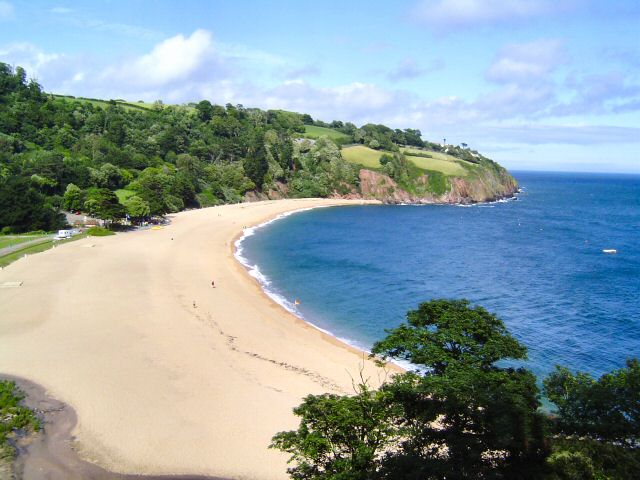
The bus shelter at Blackpool sands erected in conjunction with the establishment of the new Coast Path. This was designed locally to ensure it fits into the landscape and built by local craftsmen. On the first part of the walk there is a superb view along the coast from this area, over Blackpool Sands, Slapton Sands and Ley and on to Start Point with its lighthouse.
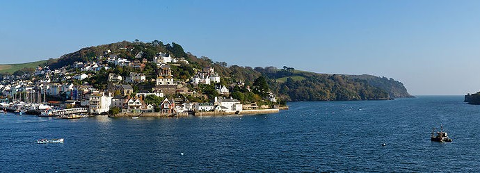
A narrow lane is called Old Road. As the name suggests, it is the original road to Stoke Fleming, being superseded by the current main road built by the Kingsbridge-Dartmouth Turnpike Trust during the early 19th century. This new road became necessary as the increasing use of coaches meant that Old Road was becoming too narrow and steep for their use. In Stoke Fleming the proximity of the pub to the church is no accident. Probably dating from the 17th century, the Green Dragon was likely to have originally been built as the Church House for use by the clergy and visitors. The church dates back to the 13th century, although it was enlarged later. The tower was always of importance as a landmark for sailors and marks the approach to Dartmouth Harbour, which is difficult to make out from the sea. In the 19th century a daymark was built on the opposite side of the Dart Estuary so that between the two towers sailors could get a fix on the Harbour entrance.
The route passes along Blackpool Valley, an attractive feature cutting deep into the surrounding landscape. Blackpool Farm was till the late 1800s Lower Blackpool Corn Mill, the reason for the name of the track (Mill Lane) and also for the woodland on the left, which is Millhill Copse. The origin of the farm as a mill can clearly be seen from the architecture. Some attractive thatched cottages date back to the late 1700s and greatly add to the charm of the location.
A packhorse bridge was built to carry the new path over the Blackpool Stream, being designed to fit in with the landscape at this attractive spot and to reflect the design of the road bridge. The current road bridge is probably 18th century in date, built by the Kingsbridge-Dartmouth Turnpike Trust when the road was improved at that time. However, a written reference to Blackpool Bridge of 1809 describes it as being only 4 feet wide, so an earlier bridge is probably incorporated in this rebuilding. There is some evidence for this by the existence of the date 1652 found on the downstream side of the bridge. To match this, a date stone engraved 2004 has been built into the new bridge.
Along Widewell Lane, there is a riot of colour in the spring from the hedgerow flowers. There are also some super views to the left over the Blackpool Valley and Sands.
Strete village church, as Devon village churches go, is relatively new, being built in 1836, although the tower is much earlier. This is because Strete was originally part of the parish of Blackawton, some miles inland. The church was built as a chapel for the village, to avoid the need to travel to Blackawton. Strete became a separate parish in 1881. A little further down the road the Laughing Monk restaurant occupies the old village school. As can be seen by the date stone, this goes back to 1859. Strete was evacuated between 1943 and 1944 when the area was the site of preparations for the D-Day landings and these valleys, so quiet and peaceful now, were important wartime training areas. The views from the coast path in this section are stunning, encompassing a wide vista from Start Point on the far right, over Slapton Sands and the Ley and round to the left to the Mew Stone and Froward Point, beyond the Dart Estuary. The importance of Stoke Fleming church as a landmark is clear from here.
Landcombe Valley is a striking feature. Until the relatively recent past it was criss-crossed by hedges which divided it into a number of small fields. The lines of these field boundaries can be made out here and there. Along Widewell Lane, the Coast Path has to be inland of the main road because there is no room on its seaward side at the headland of Matt’s Point, where there have also been cliff falls in the past. The views over Blackpool Sands from here are stunning. In medieval times this area would have looked quite different, most of the valley bottom appearing at that time as a wet, boggy area from where the name “the black pool” arose. Today it can look idyllic, the almost Mediterranean appearance accentuated by the evergreen pines which have been planted around the valley by the landowners to enhance the environment. Close to here is holm oak, planted in the 1890s as a memorial by the present landowner’s great-grandfather on the birth of his first son.
In 1404 Blackpool Sands was the site of a bloody battle. Breton forces had landed at Slapton and made their way along the coast intending to plunder Dartmouth. However, they were overwhelmed by the local militia, especially the archers, helped by the stone-throwing of the women folk and by the fact that the heavily armoured Breton knights on horseback foundered in the “black pool”. An information board by the beach gives some more information about the Battle of Blackpool.
