Interesting information
This is a one way walk, but buses back to the start at Exeter from Starcross are sufficiently frequent that there should be no concern about how long is taken for the walk. Walking towards the sea allows you to experience the range of environments from historic quayside to wide, open estuary, the urban influence gradually being left behind.
There seems to have been a quay in Roman times, located at Exeter Quay and possibly even before. However, it was substantially enlarged and reorganised in the 1670s, when its current shape emerged. Particularly notable is the Custom House, built 1680-81 and said to be the first brick building in Exeter. It is a reminder of the City’s former importance as a port, at times the third or fourth most important in the country. Opposite is the fish market, an open 19th century ironwork structure. Downstream, the large early 19th century warehouses are also attractive.
The leat is one of a number which were formerly used for driving industrial machinery in what was once the City’s main industrial area.
Just after the Piazza Terracina [named after Exeter’s twin town in Italy], is the basin of the Exeter Canal. Although the Basin is of later date, the first part of the canal was completed in 1567, making it the first inland waterway to be built in England. It was built to by-pass a weir which had been constructed across the Exe by the Countess of Devon in the late 13th century. This had the effect of cutting off Exeter’s link to the sea and thus boosting the Countess’s port at Topsham, at the head of the estuary. The canal was successful, as seen by the Customs House and warehouses at the Quay.
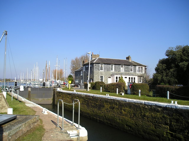
The lock gives access from the canal to the river and quay. Together with the basin, it was constructed in its present form in the early 19th century.
The canal is parallel to the Exe for its entire length, generally close to it although sometimes further away. Along much of this length the line of trees alongside the river can be seen to the left, and occasionally the river itself is visible.
The pound locks were first built when the canal was originally constructed in the 16th century, making them the earliest in England. They were rebuilt later, probably by Dutch engineers, and the design of the Double Locks Inn, which was built in the late 17th or early 18th century, shows Dutch influence.
Further on can be seen the houses of Countess Wear village. The village gets its name from the Countess Isabella who built the weir across the Exe here in the late 13th century, thus cutting off Exeter’s link with the sea and prompting the building of the canal.
The old Exeter by-pass, notorious for its holiday weekend traffic jams in the 1960s and 70s. It crosses the canal on two separate bridges, a lifting bridge and a swing bridge.
For those who feel they have walked far enough, buses back to Exeter can be caught from Countess Wear, along the road.
The earliest stage of the canal ends just downstream of the Countess’s weir. The next section, to Topsham, was added in the 17th century.
Having passed under the M5, the aspect becomes decidedly rural. Over the fields to the right is the village of Exminster. This is an ancient settlement, dating to the early years of the Saxon occupation of Devon. Its name [the Minster on the Exe] shows it to be the site of a very early church.
The attractive location of Topsham Lock gives good views over the river to Topsham, which can be reached by a seasonal ferry. It also marks the end of the canal as it was extended in the 17th century. The lock which gave access to the river is just above the ferry crossing.
The next, lowest, part of the canal was added in the early 19th century. It runs closely parallel to the Exe, separated only by a narrow spit of land covered in reed beds.
The Exminster Marshes once part of the estuary, they have been reclaimed by a network of drainage ditches. They still comprise extensive wetlands however, and form part of the important Estuary wildlife habitat.
Further on, look over the canal to the river beyond. Around here the Exe is joined by a major tributary river, the Clyst, and together they combine to form the now extensive estuary.
Turf Lock marks the end of the canal. Another attractive location, it offers superb views down the estuary. The lock and the inn both date to 1825, when the final canal extension was built.
The superbly scenic estuary-side path gives unparalleled views over the Exe and the marshes. The estuary is of international importance for its wintering wildfowl and waders and also has many rare plant species. In addition, the estuary sandbanks support communities of invertebrates of national significance. In winter over 10,000 wildfowl and 20,000 waders may be on the estuary, which also carries the largest current flock of wintering avocets in Britain.
The 15th century Powderham Church, a church with no village which was built to serve Powderham Castle. The grounds of Powderham Castle, home of the Courtenays, Earls of Devon. The 15th century castle is seen on the skyline. Alongside the road is the deer park, and the estate’s deer are usually visible here.
The distinctive tower of the pumping station for the South Devon Atmospheric Railway can be seen along the walk. When the railway line was first built by Brunel in the 1840s he had the idea of propelling the trains by a vacuum system using pipes between the rails connected to the locomotives. The vacuum was created by a series of pumping stations, of which the Starcross one is perhaps the best surviving example. Although a novel idea, it never really worked and was abandoned after three years.


