Interesting information
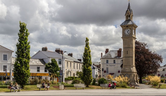
The walk begins at The Square, at the town end of Barnstaple Bridge, distinguished by its Albert Memorial Clock Tower of 1862.
Now Fremington Manor Nursing Home, this imposing building was re-modelled in the 1880s for the local Yeo family. It is based on a previously existing 18th century house.
In early times the River Taw it was Fremington’s main means of access and communication. The footpath and parallel tracks indicate the lines of early links between the village and the Taw.
An early railway was constructed to take cargo from Fremington to Barnstaple. This was in the 1840s, and originally the wagons were horse drawn. Its importance arose from the fact that the Taw had become difficult to navigate all the way to Barnstaple because of silting. A little later a broad gauge line was laid the whole way from Barnstaple to Bideford, but it became standard gauge when it fell under the control of the London and South Western Railway in the 1860s. Later, it was extended to Torrington and later still to Halwill, primarily to deal with clay traffic from the Marland and Petrockstowe quarries. Although passenger services stopped in the 1970s, the line continued to carry clay until the 1980s. After closure it was purchased by Devon County Council and reconstructed as a cycle and walkway.
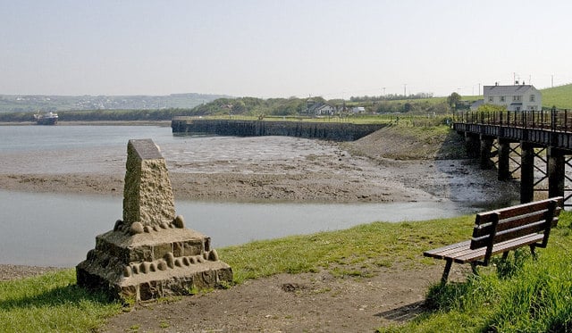
The viaduct is a vantage point for views up Fremington Pill and over the Taw Estuary. The building on the opposite bank of the Taw is Heanton Court, an 18th century rebuild of a much older building, the home of the Bassett family. On the hillside to the left can be seen the tower of Heanton Punchardon church.
By the 19th century the silting of the Taw had made it difficult for larger boats to get to Barnstaple, and the importance of Fremington as a port increased substantially. The Quay was developed to handle this increased trade. Imports included coal for fuel and limestone for fertiliser (look for the 19th century limekiln on the left of Fremington Pill), while the main export was ball clay, brought first by road then by rail. In the mid 20th century Fremington was the biggest port in tonnage handled between Bristol and Land’s End.
The old station here has now been developed into a cafe, bike hire and visitor centre, including a superb look-out over the estuary. Views encompass Heanton, Chivenor airfield and the extensive dune system of Braunton Burrows.
The bridge carries a bridleway back to the Barnstaple – Fremington road in one direction, or to a vantage point on the estuary shore the other way. This latter is a cul-de-sac, so if you go to this point you will have to return here.
The marshland is a formally designated Site of Special Scientific Interest, of major importance for its over-wintering and migratory populations of wading birds. The total number of waders on the estuary in winter can reach more than 20,000. The marshland is also important for its range of estuarine plants, including some rarities, and for invertebrates in the mud banks.
Pilton is now a suburb of Barnstaple, but was once a town in its own right, traditionally said to be older than its neighbour. It is said to be the site of one of Devon’s original four Anglo-Saxon boroughs.
The curving path follows the route of a railway loop which carried the line on towards IIfracombe, crossing the Taw next to the road bridge.
The bridge was probably originally built in the 13th century. Improved in the 1430s and again in the 1580s it has 16 stone arches, 13 of them medieval. It was last widened in the 1960s.
The station served the line to IIfracombe. It was also the terminus of the Lynton and Barnstaple Railway, a narrow gauge line which operated between 1898 and 1935. A thriving Society exists to promote the history and knowledge of this railway and to attempt to re-open lengths of what was a fascinating and scenic route.
The mound is the site of Barnstaple’s medieval castle. This existed by the early 12th century, an artificial mound surmounted by a stone tower with walls 10feet/3m thick, all surrounded by an outer wall. It appears to have been in some disrepair as early as the 1300s.
The High Street is of Saxon origin and bisects the area of the medieval town.
The church is very attractively located. Note especially the twisted spire, dating from 1389. Take your time to look round the church and study the guide. Just beyond the church is St. Anne’s Chapel, an early 14th century building used more recently as a museum. Opposite, Church House, built as a Sunday School, is much more recent, dating from the 1890s.
The lane leads past Paige’s Almshouses (no’s 1-2), dating from 1656 and then past Horwood’s Almshouses (1674) and Horwood’s School. The latter, now a café, was built and established as a girls’ school in 1659.


